 Seal River Journal 2009
Seal River Journal 2009
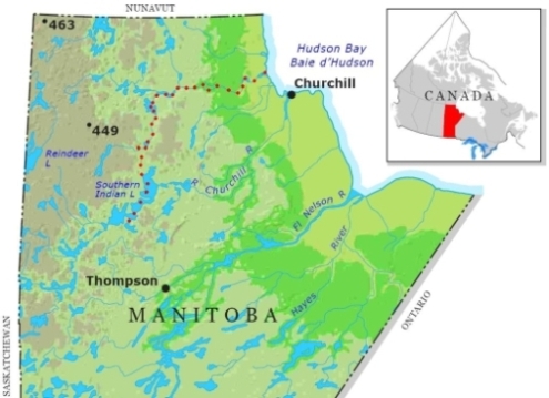
Seal River Journal 2009| The Seal River system is located in Northern Manitoba, the majority of canoe trips start on Tadoule Lake and end at the Hudson Bay. Some groups extend the route by starting further upstream on either the North or South branches adding an additional 8 - 10 days.
Our "group" consisted of my regular paddling partner of ten years, Stockbridge Steve from MA and myself (Ben aka Recped). I had paddled the Seal from Tadoule in 2006 with another small group, Steve had been upset he had missed the trip and I was quite willing to return. We were looking for a longer trip, the initial choice was to access via the North Seal, it offered a nice downhill paddle all the way whereas the South route looked potentially more difficult, information was also somewhat scarce. Unfortunately the ultimate cost of the fly-in to Chatwin Lake proved more than our budget could handle. We then turned to the South option, the choice there was a much shorter flight into Big Sand Lake or to somehow traverse the length of the rather huge South Indian Lake and go upstream on Little Sand Creek, crossing over the height of land and making our way through a series of small-connected lakes to the South Seal. After a number of telephone calls I made contact with a resident of the First Nations community of South Indian Lake who claimed they could arrange for a boat shuttle to the Northeast end of South Indian Lake, a distance of about 125km. Only one problem, at this date, June 20th South Indian is still frozen solid, about 3 weeks or more later than in a normal year. Our final route was now determined, we planned to leave Toronto by car on July 1st and hoped to have our boat shuttle on the 6th. We have allotted a minimum of 21 days with 24 days being the fall back in case of delays. Our schedule is somewhat constrained by needing to co-ordinate with Jack Batstone who will pick us up by motorboat at the mouth of the Seal, he will be taking us to Churchill where we will catch the train back to Thompson, the train runs 3 times weekly, we want to avoid ending up sitting around in Churchill any longer than necessary. As is our usual preference we will be paddling two solo canoes, I will be paddling a Mad River Guide, Steve will be using a Swift Raven, my Guide has a full deck, the Raven will have one of Steve's patented makeshift spray shield setups.
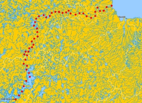
Maps show our daily GPS track, generally speaking the direction of travel is bottom to top and/or left to right; note that the scale varies from map to map.
Check out the Gallery for a a full selection of pictures plus a narrated presentation
Please send comments, qestions, bug reports or anything else that strikes your fancy |
| All text and images contained herein © 2010 - Unauthorized use may be hazardous to your health.
This story is fiction. Any resemblance of the events, names, personalities, places, or organizations in this story to actual names or events is coincidence. There may be a river of this name; it's even possible that persons paddling a canoe may be able to navigate a route similar to the one described herein. To attempt such a journey based on the fictional hallucinations related on these pages would be foolhardy at best. |